

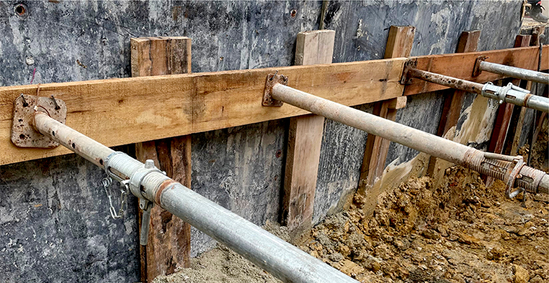
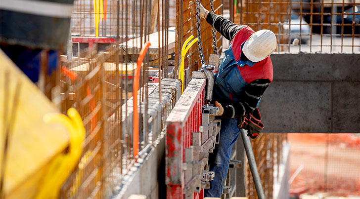
Shoring Plans by ACCE
Basement construction for restidential properties allows homeowners to achieve the maximum square footage within the allowable building envelope. Often space limitations prevent access through an open cut. To achieve these designs, the closely adjoining property and improvements must be safely supported throughout the construction. Shoring makes this happen.
Shoring is a system that functions to retain earth, water, and adjacent structures when an excavation is required. Our professional engineers are ept in investigation and situational receptiveness thus delivering thorough site specific drawings and calculations.
ACCE's Shoring Services include:
- In-house engineered design drawings and structural calculations
- Best-in-class safety standards
- Permitting and communication with relevant municipal authorities
Contractors can often develop their own shoring designs for excavations. But there are times when they need guidance, stamped drawings from a Professional Engineer (PE).
Contact us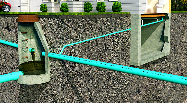
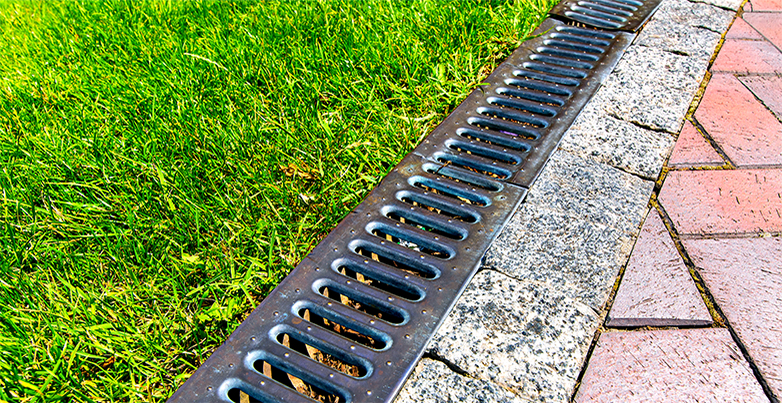
Drainage & Sewer Plans
Did you know that California is the 10th driest state with approximately 22.4 inches of annual percipitation. The unpredictability of mother nature's showers and storms can quickly add inches or feet of water to a property with poor drainage. It is very important that all structures are equiped to handle stormwater runoff. As a matter of fact even ancient builders took that into consideration. According to RoadEx.org, the first roads appeared some 3500 years ago.
What about Sewage?
A sanitary sewer system design is just as critical. Everyone uses the bathroom right? The average person flushes a toilet 5 times per day, and the national average for a gallon of water is 2/10ths of a cent per gallon. Besides water waste, no pun intended :), last thing you need is a broken pipe, leading to septic issue, and for the matter, a smelly home/building. Our engineers have extensive experience in complex drainage projects and can deliver hydrologic and hydraulic design calculation.
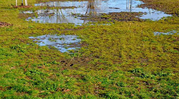
Positive Drainage
Water might be the planet’s life force, but it can cause plenty of problems if allowed to sit in your backyard, sidewalks or roadways. Without proper drainage analysis, a structure runs the risk of flooding, foundational damage, and in worst-case scenarios erosion and even sinkholes. The primary goal of any civil engineers grading design is to make sure that stormwater flows off of the site in a safe efficient manner to avoid standing / still water. The ultimate goal is to maintain positive drainage, i.e the flow of water away from its original location.
Things to consider when designing a drainage system:
- The lay of the land (Hillside, Flat, etc)
- Altitude
- Local Vegetation
- Traffic Patterns
These technical specification will ensure positive drainage:
- The slope of the main access drive shouldn't exceed 8%
- Parking lot slopes shouldn't exceed 5%
- the slope within grassed areas Shouldn't exceed a 3:1 or 33%
- The maximum slop in stabilized landscaped areas cannot exceed 2:1
- Asphalt should have a 1.5% minimum slope
- Concrete areas and concrete curbs should have a minimum slope of 0.75%
- The first 60 feet of a loading area should maintain a minumum slope of 2%
Our engineers at ACCE will be happy to assist in your drainage analysis.
Contact us
Sources:
- https://s3.amazonaws.com/suncam/docs/188.pdf
- https://en.wikipedia.org/wiki/Grading_(earthworks)
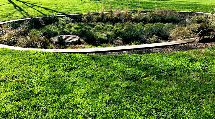
Low Impact Development
As per EPA.gov, the term low impact development (LID) refers to systems and practices that use or mimic natural processes that result in the infiltration, evapotranspiration or use of stormwater in order to protect water quality and associated aquatic habitat. EPA currently uses the term green infrastructure to refer to the management of wet weather flows using these processes, and to refer to the patchwork of natural areas that provide habitat, flood protection, cleaner air and cleaner water. At both the site and regional scale, LID/GI practices aim to preserve, restore and create green space using soils, vegetation, and rainwater harvest techniques. LID is an approach to land development (or re-development) that works with nature to manage stormwater as close to its source as possible. LID employs principles such as preserving and recreating natural landscape features, minimizing effective imperviousness to create functional and appealing site drainage that treat stormwater as a resource rather than a waste product. There are many practices that have been used to adhere to these principles such as bioretention facilities, rain gardens, vegetated rooftops, rain barrels and permeable pavements. By implementing LID principles and practices, water can be managed in a way that reduces the impact of built areas and promotes the natural movement of water within an ecosystem or watershed. Applied on a broad scale, LID can maintain or restore a watershed's hydrologic and ecological functions.
Core requirements to designing LID
- Conserve natural areas where possible
- Minimize the development impact on hydrology
- Maintain runoff rate and duration from the site
- Implement pollution prevention strategies
With the growing demand for Environmental reservation, Awareness and Sustainability, Low Impact Development has become a staple amongst our Community of Builders.
Contact us
Sources:
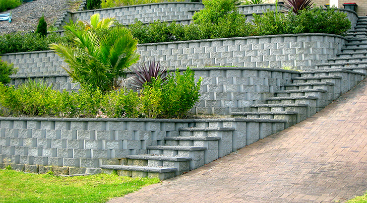
Retaining Walls - ACCE
A retaining wall is the structure designed to uphold the soil behind it or different materials. These walls provide lateral support to vertical slopes of soil, like after digging for a pathway, patio or any other landscaping project. They can also be used in various other projects, like roads, bridges, irrigation engineering, etc. Without a proper path to release water that builds up in the slope behind it, the pressure applied by water in the soil would crack or even buckle the wall. Implementing weep holes with lengths of 3/4 pipe will help drive the water out through the gravel by percolation.
There are several types of Retaining Walls and are project dependent to name a few:
Mechanical Stable Earth Walls
- Concrete Block Walls
- Panel Walls
- Temporary Earth Walls
Conventional Holding Walls
- Gravity holding Walls
- Semi-Gravity holding Walls
- Cantilever holding Walls
- Counterfort or braced holding Walls
- Stilt Walls
Retaining walls require a permit when the retaining wall retains earth. Our professional engineers will determine if a building permit is required and help you with process.
Contact us
Sources:
- Wikipedia.org
- Civiltoday.com
- http://www.cslb.ca.gov

Site Grading Plans
A Site Grading Plan & Earthwork Estimate go hand in hand because they are both related to grading; an engineering technique of adusting the slope and soil elevation of the ground surface on and around the consturction site. The purpose of these plans and estimates is to mainly ensure an even surface and a solid foundation of a landscape improvement project, a new home construction or the building of a bridge / railway.
Buy doing the work, an engineer and an excavation specialist can:
- Prepare soil for a solid building’s foundation
- Ensure adequate draining
- Create artistic landscape contouring
A proper site grading design blends the existing natural landscapes seemlesly to create a beautiful shape. The shape of the site's topography is characterized by countours and spot elevations.
What is Contour Grading?
Contours are hypothetical lines on a grading plan that depict a 3-demensional topography of your project's ridges, valleys and depressions. Contour intervals are lines used to measure elevation and terrain's shape by connecting lines drawn on a map of equal elevation. In reality these lines would illustrate the shape of the land's surface. For example, if your map uses a 10-foot contour interval, you will see contour lines for every 10 feet (3 meters) of elevation — lines at 0, 10, 20, 30, 40 and so on. Different maps use different intervals, depending on the topography. If, for example, the general terrain is quite elevated, the map might run at 80- to even 100-foot (24- to 30-meter) intervals. This makes it easier to read the map, too many contour lines would be difficult to work with.
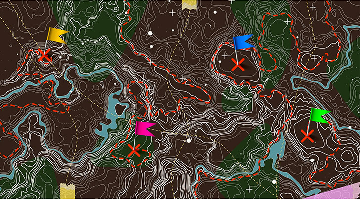
What is Spot Elevation?
Spot elevations are more accurate than contour lines and are usually indicated on topo maps like the one above, by a cross, a dot or an X. They show highest and lowest points like the summit of a hill and top or bottom of a retaining wall which are critical to a site.

Earthwork Estimates
Earthwork Estimates are another cruical piece to the puzzle. They are used to measure the amount of excavated or filled soil. A Site grading design that balances, would have an equal amount of earth fill vs earth cut, and would eliminate the need to import or export soil.
A detailed site grading plan and earthwork estimate would:
- Provide a clear timeline of the work needed
- Be cost effective
- Help establish a basis for crew size and equipment type
We offer expert site grading and civil earthworks engineering services to ensure your site meets the required California Code. Properly designed grading plans can save on overall material movement resulting in significant cost and schedule savings. We also offer cut and fill estimates to Architects and General Contractors for residential and commercial projects.
Contact us
Sources:
- http://www.wikipedia.org
- http://www.civiltoday.com
- Geokov Edu
- Howstuffworks.com
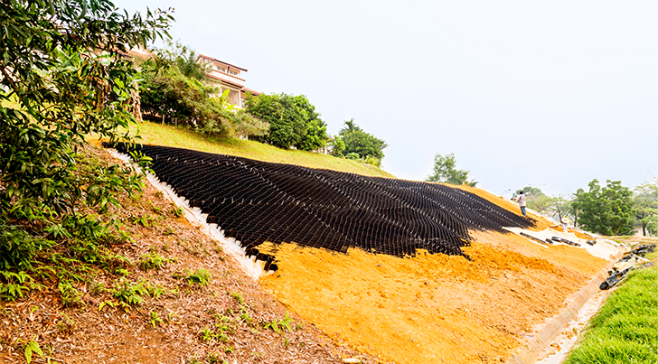
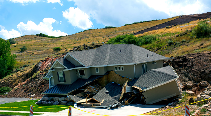
Erosion Control
Our skilled, experienced and licensed Civil Engineers at ACCE offer quality Erosion Control services for projects with quick turnaround time. Erosion and sediment control is a big part of a site design to maintain functionality and environmental responsibility. Site-specific techniques are adapted to impart soil stability in delicate areas caused due to slope failure, grading operations or for stabilizing a water body bank.
Taking these measures help:
Erosion from rainfall causes soil to move which in turn accelerates landslides. Earthquakes and volcanic eruptions also contribute to the cause. You can’t stop the rain, but you can channel rainwater in a way that prevents erosion in your home’s vicinity. Besides reducing the risk of landslides, proper drainage will ensure that rainwater doesn’t flood your property and destabilize your home’s foundation.
- Channeling rainwater using proper drainage prevents destabilization
- Erosion blankets can help stabilize a slope
- Vegetation naturally controls erosion
- A retaining wall can also help to reduce erosion
Our professional team is read to answer and assist with any questions or concerns.
Contact us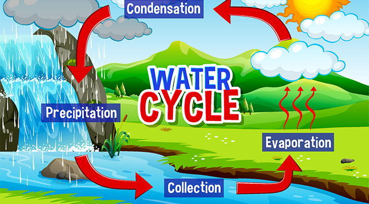
Hydraulics & Hydrology
Hydrology, which comes from the Greek word Hydro, meaning water, is the scientific study of percipitation and evaporation as well as the movement and distribution of water above and below the earth's surface in relation to the environment. Our experienced professional at All Cities Consulting Engineers can give you a clear assesment on:
- Water Cylce
- Water Resources
- Enviromental Watershed ustainability
- Impact of Human Activity
Thank you for choosing ACCE for your engineering needs.
Contact us
Sources:
- National Geographic
- Wikipedia.org
- http://www.cslb.ca.gov

Title 24 Energy Calculations
California’s energy code is designed to reduce wasteful and unnecessary energy consumption in newly constructed and existing buildings. The California Energy Commission updates the Building Energy Efficiency Standards (Title 24, Parts 6 and 11) every three years by working with stakeholders in a public and transparent process.
Compliance Resources:
- Online Resource Center
- Solar Assessment tools
- Blueprint Newsletter
- California Climate Zone map
- Manufacturer Certified Equipment, Products/Devices
- Special Cases for Building Energy Efficiency Standards
Thank you for choosing ACCE for your engineering needs.
Contact us